![]()
![]()


Interface between R and the OpenStreetMap-based routing service OSRM

OSRM is a routing service based on OpenStreetMap data. See http://project-osrm.org/ for more information. This package enables the computation of routes, trips, isochrones and travel distances matrices (travel time and kilometric distance) with R.
This package relies on the usage of a running OSRM service (tested with v6.0.0 of OSRM).
You can run your own instance of OSRM following guidelines provided
here. A
simple solution is to use docker
containers and you can find and exemple of building a European-wide
OSRM Server here.
Alternatively, you can use osrm.backend,
an R package that installs and controls OSRM executables to prepare
routing data and run/stop a local server.
⚠ You must be careful using the OSRM demo server and read the about page of the service:
osrmTable() uses the table service to query
time/distance matrices,osrmRoute() uses the route service to query
routes,osrmTrip() uses the trip service to query
trips,osrmNearest() uses the nearest service to
query the nearest point(s) on the street network,osrmIsochrone() and osrmIsodistance() use
multiple osrmTable() calls to create isochrones or
isodistances polygons.This is a short overview of the main features of osrm.
The dataset used here is shipped with the package, it is a sample of 100
random pharmacies in Berlin (© OpenStreetMap
contributors) stored in a geopackage file.
osrmTable() gives access to the table OSRM
service. In this example we use this function to get the median time
needed to access any pharmacy from any other pharmacy.
library(osrm)
library(sf)
pharmacy <- st_read(system.file("gpkg/apotheke.gpkg", package = "osrm"),
                    quiet = TRUE)
travel_time <- osrmTable(loc = pharmacy)
travel_time$durations[1:5,1:5]
## 1 2 3 4 5
## 1 0.0 21.1 33.4 21.2 12.6
## 2 22.1 0.0 42.3 16.1 20.2
## 3 33.0 43.0 0.0 30.5 27.4
## 4 20.1 15.3 29.7 0.0 12.7
## 5 10.2 20.3 26.8 12.3 0.0diag(travel_time$durations) <- NA
median(travel_time$durations, na.rm = TRUE)## [1] 21.4The median time needed to access any pharmacy from any other pharmacy is 21.4 minutes.
osrmRoute() is used to compute the shortest route
between two points. Here we compute the shortest route between the two
first pharmacies.
(route <- osrmRoute(src = pharmacy[1, ], dst = pharmacy[2, ]))## Simple feature collection with 1 feature and 4 fields
## Geometry type: LINESTRING
## Dimension: XY
## Bounding box: xmin: -13177 ymin: 5837172 xmax: -3875.06 ymax: 5841047
## Projected CRS: WGS 84 / UTM zone 34N
## src dst duration distance geometry
## 1_2 1 2 21.68333 12.5251 LINESTRING (-13170.51 58410...This route is 12.5 kilometers long and it takes 21.7 minutes to drive through it.
plot(st_geometry(route), main = "Route")
plot(st_geometry(pharmacy[1:2,]), pch = 20, add = T, cex = 1.5)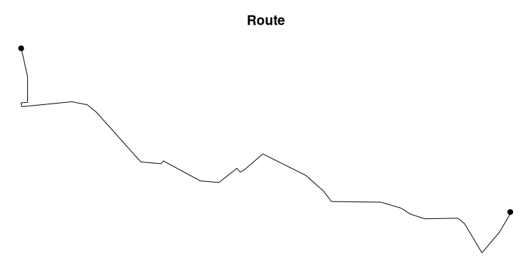
osrmTrip() can be used to resolve the travelling
salesman problem, it gives the shortest trip between a set of unordered
points. In this example we want to obtain the shortest trip between the
first five pharmacies.
(trips <- osrmTrip(loc = pharmacy[1:5, ], overview = "full"))## [[1]]
## [[1]]$trip
## Simple feature collection with 5 features and 4 fields
## Geometry type: LINESTRING
## Dimension: XY
## Bounding box: xmin: -13431.44 ymin: 5837172 xmax: -3875.322 ymax: 5856333
## Projected CRS: WGS 84 / UTM zone 34N
## start end duration distance geometry
## 1 1 2 21.68333 12.5251 LINESTRING (-13170.77 58410...
## 2 2 4 16.26667 8.4495 LINESTRING (-3875.322 58379...
## 3 4 3 30.04667 18.1690 LINESTRING (-7444.513 58427...
## 4 3 5 27.85167 16.4466 LINESTRING (-8024.73 585621...
## 5 5 1 9.80000 4.2308 LINESTRING (-11716.82 58435...
##
## [[1]]$summary
## [[1]]$summary$duration
## [1] 105.6483
##
## [[1]]$summary$distance
## [1] 59.821The shortest trip between these pharmacies takes 105.6 minutes and is 59.8 kilometers long. The steps of the trip are described in the “trip” sf object (point 1 > point 2 > point 4 > point 3 > point 5 > point 1).
par(mar = c(0,0,3,0))
mytrip <- trips[[1]]$trip
# Display the trip
plot(st_geometry(mytrip), col = c("black", "grey"), lwd = 2, main = "Trip")
plot(st_geometry(pharmacy[1:5, ]), cex = 1.5, pch = 21, add = TRUE)
text(st_coordinates(pharmacy[1:5,]), labels = row.names(pharmacy[1:5,]),
     pos = 2)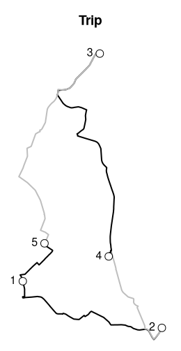
osrmNearest() returns the nearest point(s) on the street
network from any point. Here we will get the nearest point on the
network from a couple of coordinates.
pt_not_on_street_network <- c(13.40, 52.47)
(pt_on_street_network <- osrmNearest(loc = pt_not_on_street_network))
## Simple feature collection with 1 feature and 2 fields
## Geometry type: POINT
## Dimension: XY
## Bounding box: xmin: 13.39671 ymin: 52.46661 xmax: 13.39671 ymax: 52.46661
## Geodetic CRS: WGS 84
## id distance geometry
## loc loc 439 POINT (13.39671 52.46661)The distance from the input point to the nearest point on the street network is of 439 meters
osrmIsochrone() computes areas that are reachable within
a given time span from a point and returns the reachable regions as
polygons. These areas of equal travel time are called isochrones. Here
we compute the isochrones from a specific point defined by its longitude
and latitude.
(iso <- osrmIsochrone(loc = c(13.43,52.47), breaks = seq(0,12,2), n = 1000, smooth = F))## Simple feature collection with 5 features and 3 fields
## Geometry type: MULTIPOLYGON
## Dimension: XY
## Bounding box: xmin: 13.32727 ymin: 52.41842 xmax: 13.50226 ymax: 52.51358
## Geodetic CRS: WGS 84
## id isomin isomax geometry
## 1 1 0 4 MULTIPOLYGON (((13.4315 52....
## 2 2 4 6 MULTIPOLYGON (((13.44048 52...
## 3 3 6 8 MULTIPOLYGON (((13.44946 52...
## 4 4 8 10 MULTIPOLYGON (((13.4315 52....
## 5 5 10 12 MULTIPOLYGON (((13.44048 52...bks <- sort(unique(c(iso$isomin, iso$isomax)))
pals <- hcl.colors(n = length(bks) - 1, palette = "Light Grays", rev = TRUE)
plot(iso["isomax"], breaks = bks, pal = pals,
main = "Isochrones (in minutes)", reset = FALSE)
points(x = 13.43, y = 52.47, pch = 4, lwd = 2, cex = 1.5)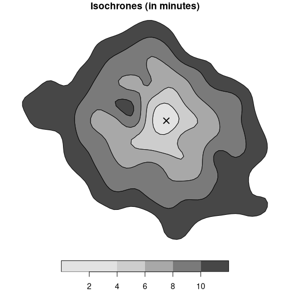
You can install the released version of osrm from CRAN with:
install.packages("osrm")Alternatively, you can install the development version of
osrm (the dev branch) from r-universe with:
install.packages("osrm", repos = "https://riatelab.r-universe.dev")One can contribute to the package through pull requests and report issues or ask questions here. See the CONTRIBUTING.md file for detailed instructions.
Many thanks to the editor (@elbeejay) and reviewers (@JosiahParry, @mikemahoney218 and
@wcjochem) of the
JOSS article.
This publication has led to a significant improvement in the code base
and documentation of the package.